 Drone IR spectrometry can add significant value to environmental surveys such as crop and drought monitoring, slope stability and landslides and the determination of the chemical and/or mineralogical composition of environmental pollutants. Measurements can be taken from surface but also, more efficiently, from the air. Using drones instead of manned aircrafts for airborne surveys allows us to collect data from a lower altitude, resulting in improved detail and quality. At the same time the use of drones reduces the cost of airborne surveys considerably.
How does it work? Many organic and inorganic materials absorb incoming (sun)light at very specific wavelengths. These absorption wavelengths are often diagnostic for compositional properties of those materials, such as (soil) minerals and vegetation,and therefore can be used to quickly identify subtle changes in chemical/structural properties of these materials. These changes can, in return, reflect changing environmental processes and therefore be used to detect and monitor the environmental impact of activities such as mining, industry and agriculture.
Mining-related environmental monitoring
T&A Survey Drone Services has used
IR spectrometry to assess the environmental impact of two former mining sites in Eastern Europe. The
Vihovici coal mine in Bosnia Herzegovina and the
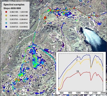
Rosia Montana Goldmine in Western Romania are both inactive, but previous mining activities have left deep environmental scars. As part of a study subsidized by the European Commission, both areas were surveyed using a combination of remote sensing data and a variety of field data, including a detailed spectral study of soil, rocks and vegetation. The goal of both studies was to determine the grade and extent of soil and surface water pollution, degradation of soil quality, and detection and delineation of landfills in the surroundings of the mines. By mapping the reflectance spectra of soils at different locations, concentrations of for example polluting substances or ore bodies can be easily located for further investigation.
Crop monitoring 
In the agricultural sector there is a great potential for application of drone technology and IR spectrometry in particular. In Groningen (the Netherlands) T&A Drone Services used IR spectrometry in a
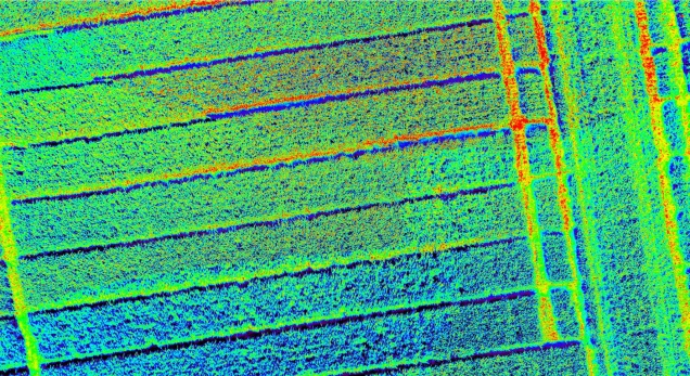
pilot project for early spectral detection of fungi in wheat fields. Early detection of such infections can significantly reduce the use of fungicides and pesticides. Using a portable IR spectrometer, spectral measurements of wheat leaves with different levels of fungus infestation were taken, ranging from healthy to strongly affected. The spectra indicate systematic spectral changes with increasing deterioration of the plants’ health. With this knowledge, drone-borne imaging spectroscopy may be used very efficiently to cover large agricultural plots with a continuous and consistent map of potential risk-areas.

 Drone IR spectrometry can add significant value to environmental surveys such as crop and drought monitoring, slope stability and landslides and the determination of the chemical and/or mineralogical composition of environmental pollutants. Measurements can be taken from surface but also, more efficiently, from the air. Using drones instead of manned aircrafts for airborne surveys allows us to collect data from a lower altitude, resulting in improved detail and quality. At the same time the use of drones reduces the cost of airborne surveys considerably.
  In the agricultural sector there is a great potential for application of drone technology and IR spectrometry in particular. In Groningen (the Netherlands) T&A Drone Services used IR spectrometry in a pilot project for early spectral detection of fungi in wheat fields. Early detection of such infections can significantly reduce the use of fungicides and pesticides. Using a portable IR spectrometer, spectral measurements of wheat leaves with different levels of fungus infestation were taken, ranging from healthy to strongly affected. The spectra indicate systematic spectral changes with increasing deterioration of the plants’ health. With this knowledge, drone-borne imaging spectroscopy may be used very efficiently to cover large agricultural plots with a continuous and consistent map of potential risk-areas.